Your carbon solution
We provide reliable soil carbon stock, distribution and flux data to support your carbon trail.
We provide reliable soil carbon stock, distribution and flux data to support your carbon trail.



Step-by-step
1. Sampling Plan
We design an optimized sampling plan tailored to your landscape with proprietary remote sensing algorithms, ensuring efficient coverage and reliable carbon stock assessment.
2. On-Site Sampling & Analysis
Our field team visits your site to collect and analyze soil samples at 10 cm depth intervals down to 50–100 cm, providing high-quality carbon stock measurements. If preferred, you can collect the samples yourself and send them to our laboratory for analysis with the aid of our easy-to-use mobile app.
3. Carbon Stock Interpolation
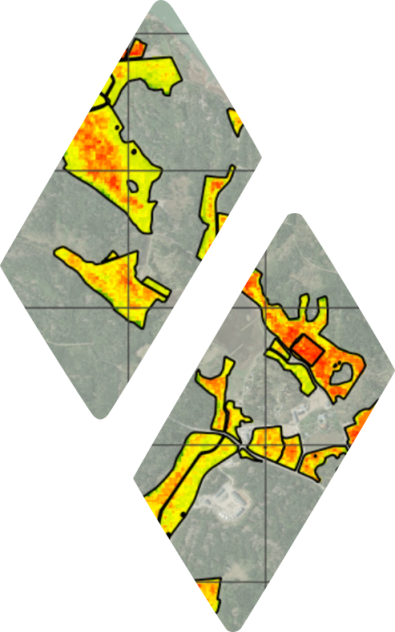
We combine the field measurements with remote sensing-based interpolation to produce detailed carbon stock maps while minimizing sampling costs.
4. Monitoring & Carbon Crediting
Repeat surveys over time quantify changes in soil carbon stocks (ΔSOC). These verified stock changes provide the removals reported in Scope 3 and FLAG inventories (GHG Protocol, SBTi FLAG) and the measured evidence required for carbon crediting under standards such as Verra (VM0042), the EU Carbon Removal Certification Framework (CRCF), and Gold Standard.
Step-by-step
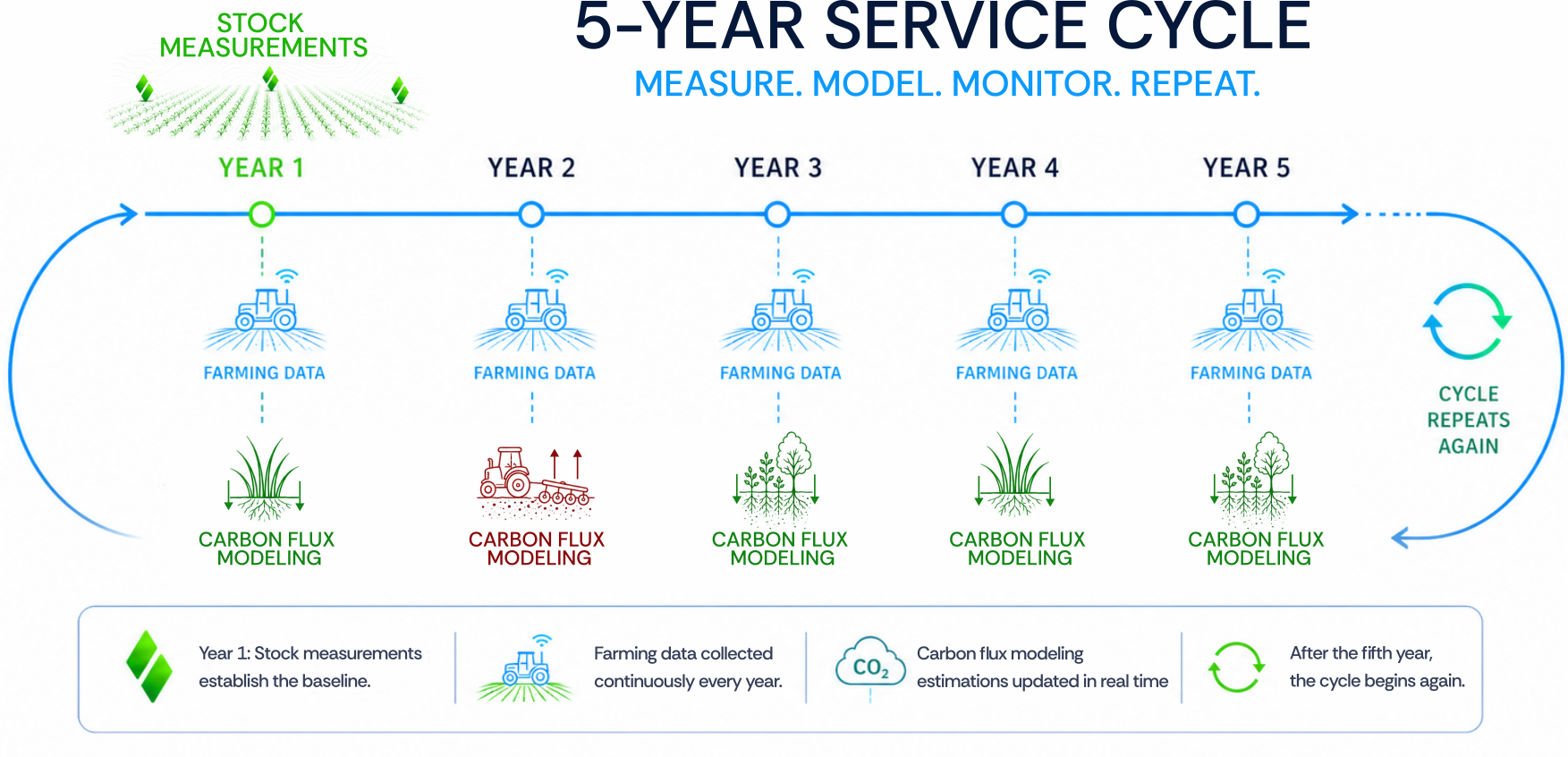
1. Initial Measurement
We measure soil carbon directly in the field, establishing the initial carbon stock for each parcel. These field measurements calibrate and validate our remote sensing models, extending accurate, plot-level carbon data across large areas without relying on satellite proxies alone. If preferred, you can collect the samples yourself and send them to our laboratory for analysis with the aid of our easy-to-use mobile app.
2. Annual Flux Modeling
Using inputs from the carbon stock measurement and farming data, we model the annual carbon balance per parcel with uncertainty reported for every estimate. This is done in collaboration with the Finnish Meteorological Institute (FMI), using its peer-reviewed CARBS method.
3. Monitoring, Crediting & Insetting
The modeled annual carbon balance provides the data needed for Scope 3 and FLAG reporting under frameworks like the GHG Protocol and SBTi FLAG. For carbon crediting and insetting, repeat field measurements re-calibrate and validate the model over time, keeping credited removals anchored to measured change. This aligns with standards such as Verra (VM0042), the EU Carbon Removal Certification Framework (CRCF), and Gold Standard.
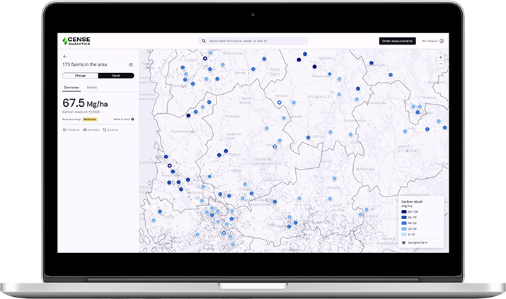
We specialize in accurate, plot-level soil carbon data. We pair fast laser-based field measurements with remote sensing, so soil carbon stocks can be mapped and monitored across large areas without sacrificing accuracy.
Our laser-based device measures soil carbon directly in the field, and these measurements calibrate and validate our remote sensing models. Together with the Finnish Meteorological Institute (FMI), the annual carbon balance per parcel is modeled using its peer-reviewed CARBS method, with uncertainty reported for every estimate.
We provide farmers with detailed insights into soil health and carbon levels, enabling them to improve crop yields, implement effective carbon sequestration strategies, and reduce environmental impact.
We help Agricultural Commodities Industries by offering precise supply chain insights, enabling them to make sustainable sourcing decisions, reduce their environmental footprint, and enhance their brand’s sustainability credentials.
We provide reliable, large-area data insight that helps assess environmental and climate risks, inform sustainable investment decisions, and support sustainable financing.
Contact us through our website to ask about the service, schedule a consultation, or request a demo.
Yes. We use a measure-and-model approach recognized by Verra’s VM0042: field measurements calibrate and validate our remote sensing, with uncertainty quantified throughout — making it suitable for carbon certification and Scope 3 reporting.
Our direct laser-based field measurements provide the ground truth that calibrates and validates our remote sensing models, so map-scale estimates stay anchored to real data rather than satellite proxies alone. Sampling is statistically designed through stratification, and results are validated by experienced agronomists and soil scientists. The annual carbon balance is computed with FMI’s peer-reviewed CARBS method, which reports the uncertainty alongside every estimate — keeping the data reliable even across large areas.
Reliable, verifiable soil carbon data lets you track and prove the impact of your land management over time, supporting carbon certification, regulatory compliance, and Scope 3 reporting with confidence. It also helps improve soil health and fertility, optimize inputs and yields, and build resilience to climate change. Over the long term, this strengthens both your sustainability credentials and your market competitiveness across the agricultural value chain.

”Cense Analytics signifies more than just the introduction of a product. It’s the opportunity to shape the future, enable sustainable practices in agriculture, and leave a lasting legacy.“
ILKKA HERLIN, CHAIRMAN OF THE BOARD
Customer case study / Blog post
Leave us your contact info and our expert for this field will get back to you.
or contact our expert directly:
paavo.kajovirta@cense-analytics.com